Dana Point

City Market · Available · Orange County, CA

A coastal city where the details matter. Dana Point is not one housing market: it spans historic hillside neighborhoods, homes directly on the sand, established production communities, resort-oriented gated neighborhoods, harbor-view residences, coastal condominiums, and some of Southern California's most significant luxury enclaves. The important differences are usually more local than the city name: community, street, elevation, view type, beach access, road exposure, lot, floor plan, and housing era.

Research Depth

City scaffold & subdivision map
Established
Six-area market hierarchy
Established
Authoritative City / HOA verification
Research In Progress
Community deep dives
Research In Progress
Builder, tract & floor-plan matrix
Research Planned
MLS market intelligence
Established

Durable research last reviewed September 1, 2026

Market Brief

Dana Point in Brief

Market Identity

A coastal city organized by headlands, bluffs, the harbor and the terraces above them. Six major market areas behave differently enough that the city name alone tells you very little about a property.

Housing Snapshot

Housing spans several eras and forms: attached coastal product and older beach-adjacent housing, conventional detached tracts on the inland terraces, and resort-adjacent and bluff-top housing near Monarch Beach and the Headlands. Governance varies from guard-gated associations to no association at all.

Common Alternatives

  • Laguna Niguel
  • San Clemente
  • Laguna Beach
Show 1 more
  • San Juan Capistrano

Key Value Drivers

  • Ocean-view type and quality, which differ sharply between whitewater, panoramic, channel and peek views
  • Beach and harbor access, which is a function of route and walkability rather than straight-line distance
  • Market area and micro-location: the Headlands, Monarch Beach, Niguel Shores, Lantern Village, Capistrano Beach, Dana Hills and Del Obispo are not substitutes
Show 1 more
  • Housing era and construction form, from older beach cottages to newer coastal product

Important Watchouts

  • View language is the most abused description in this market; classify the view type and whether it is protected
  • Coastal Zone rules affect what can be built, added or altered; confirm before assuming property potential
  • Association structures vary widely, including guard-gated systems and unassociated pockets
Show 1 more
  • Harbor revitalization is ongoing and its effects should not be quoted as a fixed value adjustment

Structured intelligence last reviewed September 2, 2026. Summarized from the published Dana Point research on this page. No pricing, view premium or insurance figure is asserted.

Quick Intelligence

Dana Point Market Intelligence

A structured summary of the durable research below. The lens narrows this summary only — the full research sections on this page are always available.

Value Drivers

Six market areas, one city name

Dana Point is read through six market areas first: Monarch Beach, the Dana Point Headlands, Lantern Village, Dana Hills, Del Obispo / Doheny and Capistrano Beach.

  • Each area carries its own housing era, form and governance
  • A citywide comparison mixes bluff-top and inland terrace product
  • Communities such as Niguel Shores sit inside this framework rather than beside it
  • Identify the area and micro-location before any price conversation
Go deeper

Headlands, bluffs, harbor and terraces

The coastline, the headlands and the terraces above the harbor organize the entire market.

  • Elevation and orientation determine what a property actually sees
  • The harbor is both an amenity and a traffic and activity context
  • Inland terrace neighborhoods behave more like conventional suburban markets
Go deeper

Buyer Fit

Classify the view before comparing anything

Buyer

Ocean view is a category, not a single feature, and the categories do not trade at parity.

  • Distinguish whitewater, panoramic, channel, harbor and peek views
  • Record which rooms hold the view and from what elevation
  • Establish whether the sight line is protected or can be obstructed
Go deeper

Access is a route question, not a distance question

Buyer

Walkability to sand or harbor depends on grade, crossings and available routes.

  • A short straight-line distance can involve a steep or indirect route
  • Parking and seasonal congestion differ by area
  • Confirm the actual walking route rather than a map radius
Go deeper

Watchouts

Association structure varies widely

From guard-gated coastal associations to unassociated older streets, governance is property-specific.

  • Confirm master and sub-association obligations for the specific parcel
  • Verify current dues, coverage and reserves from association documents
  • Some older beach-adjacent housing carries no association at all
Go deeper

Coastal Zone rules shape property potential

Additions, rebuilds and alterations in the Coastal Zone follow a separate approval path.

  • Do not assume remodel or rebuild potential without confirming coastal requirements
  • Bluff and shoreline conditions add site-specific review
  • Treat entitlement questions as verification items, not selling points
Go deeper

Seller Positioning

Price inside the market area

Seller

A Dana Point seller competes inside an area, era, product form and view class.

  • Match market area and micro-location before square footage
  • State the view class precisely rather than using generic coastal language
  • Association structure and total monthly cost belong in the positioning
Go deeper

Agent Talking Points

What separates two coastal homes

Agent Study

The variables worth coding on every Dana Point property.

  • Market area and street position relative to the bluff or harbor
  • View class, elevation and protection
  • Housing era, construction form and prior alterations
  • Association obligations and Coastal Zone constraints
Go deeper

Key Questions

  1. 01

    Is all of Dana Point a coastal-view market?

    No. The city includes bluff-top and view housing alongside inland terrace neighborhoods where the view is not the organizing variable.

    Go deeper
  2. 02

    What counts as an ocean view here?

    Views are classified by type, elevation and protection. Whitewater, panoramic, channel, harbor and peek views are different products.

    Go deeper
  3. 03

    How close to the beach is walkable?

    Access depends on route, grade and crossings rather than straight-line distance. Confirm the actual walking route.

    Go deeper
  4. 04

    Which market areas should be compared with each other?

    Compare inside one of the six market areas first: Monarch Beach, the Dana Point Headlands, Lantern Village, Dana Hills, Del Obispo / Doheny or Capistrano Beach. Communities such as Niguel Shores are compared within their area, not against the city.

    Go deeper
  5. 05

    Can a coastal property be expanded or rebuilt?

    Coastal Zone requirements apply and must be verified before assuming property potential.

    Go deeper
  6. 06

    Does the harbor revitalization change property values?

    It is an ongoing context worth understanding, but no fixed value adjustment is published for it here.

    Go deeper
  7. 07

    What do buyers cross-shop against?

    Laguna Niguel, San Clemente, Laguna Beach and San Juan Capistrano, depending on product, view and budget.

    Go deeper

Dana Point at a Glance

Durable orientation facts only. Pricing, dues, assessments and inventory are deliberately excluded from this page until they are sourced.

January 1, 1989
Date of incorporation. Most of the housing is decades older than the city itself, which is one reason municipal terminology and real estate terminology do not always line up.
About 6.5 sq. mi.
City land area, with close to seven miles of coastline. Small enough to cross in minutes, varied enough to contain a dozen genuinely different housing markets.
Six major market areas
Monarch Beach, the Dana Point Headlands, Lantern Village, Dana Hills, Del Obispo / Doheny and Capistrano Beach. This is an editorial real estate hierarchy, not a list of official planning districts.
Capistrano Unified
The district serving Dana Point addresses. Attendance boundaries are address-specific and change over time.
Coastal Zone city
Dana Point has a certified Local Coastal Program. Depending on location and project type, development can require coastal permitting.
100+ named subdivisions
Named areas on the reference subdivision map. Almost all are held here as research records rather than published profiles.

Every item above is treated as a durable fact and reviewed on a schedule. Anything property-specific belongs to the individual property, not to the city.

Where Dana Point Sits, and Why It Matters

Dana Point occupies the coast between Laguna Beach to the northwest and San Clemente to the southeast, with Laguna Niguel inland to the north and San Juan Capistrano inland to the east. Interstate 5 runs along the inland edge; Pacific Coast Highway runs the length of the city near the water.

Geography here does more than set the scene. It creates the submarkets.

  • The Headlands interrupts the coastline and gives the city its most distinctive landform, its harbor shelter and a large block of permanently conserved public coastal land.
  • The harbor anchors the center of the city and gives an entire class of property a water view that is not an ocean view.
  • Coastal bluffs run through Lantern Village, the Headlands, the Niguel Shores edge and Capistrano Beach, which is why straight-line distance to the sand is often a poor guide to beach access.
  • Terraced hillsides in Lantern Village, Monarch Bay Terrace and hillside Capistrano Beach determine which side of a street sees water and which sees rooftops.
  • Elevated inland ridges hold Dana Hills and the northern edge of the city, where the product is planned and largely inland rather than coastal.
  • Lower marine terrace and creek corridors at Doheny, the San Juan Creek corridor and lower Del Obispo sit at the opposite end of that elevation range.

Circulation shapes value too. Crown Valley Parkway, Golden Lantern, Del Obispo, Stonehill Drive, Camino Las Ramblas, Coast Highway, the rail corridor through Capistrano Beach and the I-5 edge all create exposure conditions that vary block by block.

Dana Point, Community by Community

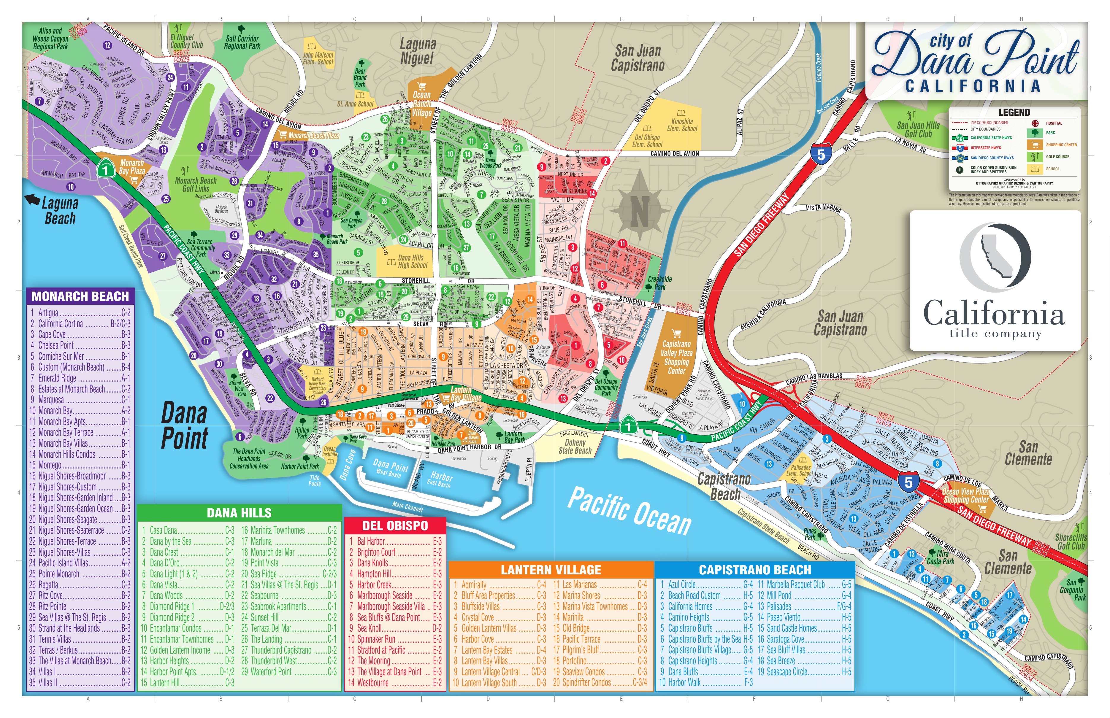
Color-coded map of Dana Point, California showing named subdivisions and neighborhoods, the harbor, Headlands, coastline, major roads, parks and schools

Pinch, scroll or use the controls to zoom. Drag to pan.

Dana Point subdivision and neighborhood reference map. Community names and boundaries are used as a geographic learning tool and should be independently verified where material to a specific property. This is not a legal parcel, tract or HOA boundary map.

The map groups Dana Point into five large color-coded areas: Monarch Beach, Dana Hills, Del Obispo, Lantern Village and Capistrano Beach. This platform separates a sixth, the Dana Point Headlands, because its land-use history, conservation framework and luxury residential product are distinct enough to study on their own. Not every label on the map is an HOA, a recorded tract, an official planning district or a future page.

How to Read the Dana Point Market

Dana Point makes the most sense when you stop treating it as a single beach city.

Start with geography. Monarch Beach, the Headlands, Lantern Village, Dana Hills, the Doheny / Del Obispo corridor and Capistrano Beach contain substantially different housing products and lifestyles.

Then move closer. A property's value can change because of the type of ocean view, whether beach access is genuinely convenient, which side of a hillside street it occupies, road or freeway exposure, HOA structure, construction era, lot orientation and neighboring development.

The purpose of this guide is to understand those differences rather than reducing Dana Point to a citywide median price.

Ocean view is not one thing

View geometry

Whitewater, panoramic coastline, open horizon, Catalina and sunset, harbor water and a framed peek of blue are different assets with different buyer pools. A listing that says ocean view has not yet told you much.

Beach-close is not beach-accessible

Access mechanics

Bluffs, highways and rail make straight-line distance misleading. Two homes equally close to the water on a map can have completely different routes to the sand.

Higher is not automatically better

Elevation

Elevation interacts with orientation, downslope construction, foreground rooftops, wind and road noise. A lower bluff home over the harbor can live better than a much higher home with a distant horizon.

Road exposure can matter dramatically

Exposure

I-5, Coast Highway, Golden Lantern, Crown Valley, Stonehill, Del Obispo, Camino Las Ramblas, Harbor Drive and the rail corridor all create exposure conditions worth treating as a first-class variable rather than a footnote.

A community name does not define the comp set

Comparables

Monarch Beach, Niguel Shores, Lantern Village and Capistrano Beach each contain products that are not substitutes for one another. The gate, the tract and the micro-location usually matter more than the name.

Ocean View Intelligence

Before comparing two ocean-view homes, it is worth naming what each one actually sees.

Whitewater

Breaking surf in view, usually with sound. Typically the narrowest and most sought-after category.

Panoramic coastline

A wide sweep of shoreline rather than a single window of water.

Open-ocean horizon

Blue water and horizon without the shoreline in frame.

Catalina and sunset

Directional and seasonal. Sunset orientation is its own value proposition.

Harbor and marina

Water, boats and evening light. A different product from open ocean, not a lesser one.

Headlands

Landform and conserved open space in the foreground or frame.

Partial or peek ocean

A framed slice, sometimes from one room or one level only.

Tract and property analysis should also record view width, foreground (water, rooftops, vegetation, utility lines), which rooms hold the view, whether it is upstairs-only, orientation, downslope construction, obstruction risk and whether sightlines are HOA-protected. The precise dollar and percentage view premiums that appear in secondary research are intentionally not published here: they require MLS paired-sale evidence first.

Beach-Close Is Not the Same as Beach-Accessible

How far a property sits from the coastline on a map is often less important than how someone actually reaches the water.

  • Direct sand frontage

    The property fronts the beach itself. A specialized market with its own title, shoreline and maintenance questions.

  • Private gated beach access

    Access controlled by a community or club rather than the public. Rights are community-specific and require verification.

  • Community trail access

    An internal path or stair maintained by the association, often the practical difference between walking and driving.

  • Public bluff or stair access

    A public route down the bluff. Convenient for some blocks, a long detour for others.

  • Harbor access

    Water access without surf. Different daily use and different parking pressure.

  • Short-drive access

    Realistically a car trip, with parking as part of the experience.

  • Proximity without pedestrian access

    Close on a map, separated by grade, a highway or rail. Common in Dana Point and easy to misread.

A more useful question than how far is the property from the ocean is simply: how do you actually get to the water?

How Dana Point Was Built

  1. Historical context

    Richard Henry Dana Jr.

    The city is named for the author of Two Years Before the Mast, whose account documented this stretch of coast.

  2. 1920s

    The Woodruff era

    Sidney H. Woodruff's development campaign established the original Dana Point vision, the Lantern street naming system, Mediterranean and Spanish-influenced architecture and much of the subdivision fabric that still shapes Lantern Village lots today. Finer historical detail, including original model and fixture counts and exact subdivision chronology, is still being verified against City historic records and the Dana Point Historical Society.

  3. 1920s - 1950s

    Early Capistrano Beach and postwar expansion

    Capistrano Beach developed as one of the area's oldest residential districts, with cottage and ranch-era housing joined by substantial postwar growth.

  4. 1960s - 1970s

    Harbor construction and the coastal communities

    The building of Dana Point Harbor reoriented the center of the city. Monarch Bay, Monarch Bay Terrace, Niguel Shores and the first Dana Hills neighborhoods date from this period.

  5. 1980s

    Inland and harbor-adjacent growth

    Additional Dana Hills production and attached housing, plus harbor-adjacent residential product.

  6. January 1, 1989

    Incorporation

    Dana Point, Capistrano Beach and Monarch Beach, previously unincorporated communities, became a single city.

  7. 1990s

    Resort-oriented gated development

    Ritz Pointe and the resort corridor bring Mediterranean-influenced gated production housing.

  8. 2000s

    Headlands entitlement and conservation

    The Headlands is planned with residential development and permanently preserved public coastal land together. Ritz Cove matures and custom luxury product expands.

  9. 2010s - 2020s

    Lantern District, Doheny Village and the Strand

    Town Center revitalization, Doheny Village planning, South Cove and Doheny-area development, continued Lantern Village infill and custom construction at The Strand.

  10. Current

    Harbor Revitalization

    A multi-phase reconstruction of the marina, commercial areas and public realm through a County of Orange public-private partnership. Tracked separately on this page as dynamic intelligence.

Where historical figures come only from secondary research, the language here is intentionally broad. Exact counts and dates are being verified before they become durable facts.

Explore Dana Point

Six major market areas. Each one contains housing that is not interchangeable with the others, and in most cases not interchangeable within itself either.

Monarch Beach

Research in progress

Resort-oriented northern coastal Dana Point containing dramatically different attached, detached, gated, golf-oriented, beach-oriented and ultra-luxury communities.

Dana Point Headlands

Research in progress

The Headlands landform, its public conservation environment and trails, Strand Beach, and The Strand at Headlands luxury enclave.

Lantern Village

Research in progress

Dana Point's historic hillside residential core around the Lantern District. Unusually varied housing, elevation, harbor and ocean views, infill and block-to-block differences.

Dana Hills

Research in progress

An inland and elevated Dana Point housing market containing significant production-home, attached and planned-neighborhood inventory.

Del Obispo / Doheny

Research in progress

Lower-elevation Dana Point around Del Obispo and Doheny, combining established residential communities with redevelopment and newer infill.

Capistrano Beach

Research in progress

A distinctive southeastern coastal market ranging from homes directly on the sand to bluff-top, Palisades, hillside and freeway-adjacent housing.

Dedicated community pages are published only once meaningful research exists behind them. Everything currently marked Research in Progress is recorded in the directory at the bottom of this page.

Monarch Beach Is Not One Neighborhood

Monarch Beach is a market system rather than a single tract or association. A buyer who says they want Monarch Beach could be describing an attached condominium, a golf-adjacent home, a gated tract residence, a single-story ocean-view property, a Niguel Shores patio home, a custom coastal residence, a private beach-club community or an ultra-luxury estate.

Monarch Bay

Research in progress

Established gated coastal community dating to the 1960s, historically associated with a long-term ground-lease structure and a private coastal club, and now seeing substantial custom rebuilding. Title and community rights differ and must be confirmed property by property rather than assumed for the community as a whole.

Monarch Bay Terrace

Research in progress

Established non-gated hillside community from the 1960s and 1970s with larger lots, meaningful single-story inventory and strong ocean-view relationships. Architectural and view controls appear important here and are being verified from association documents before anything is stated as a rule.

Niguel Shores

Research in progress

Guard-gated coastal community containing several distinct sub-tracts and housing products, attached and detached, with shared recreation and beach-access infrastructure.

Ritz Cove

Research in progress

Small gated custom coastal enclave adjacent to the Salt Creek and resort environment, dominated by custom architecture. HOA structure, beach-access rights and assessment status require verification.

Ritz Pointe

Research in progress

Gated 1990s resort-corridor community containing materially different attached and detached products, including California Cortina, Corniche Sur Mer and Monarch Hills. A Monarch Hills condominium and a California Cortina detached home serve different market segments.

Monarch Beach on its own is usually too broad to define a meaningful competitive set. Note also that The Strand at Headlands is treated here under the Dana Point Headlands rather than as another Monarch Beach tract, and that some Ritz Pointe addresses raise a Dana Point versus Laguna Niguel jurisdiction question that must be resolved at the parcel level rather than from a marketing name or ZIP code.

Niguel Shores: One Gate, Several Housing Products

The subdivision map distinguishes several named areas inside Niguel Shores. A Sea Terrace attached property and a custom bluff-oriented residence are not meaningful substitutes simply because they share a master community and a gate.

The working analysis path is: Niguel Shores → sub-tract → housing product → view and beach relationship → exact micro-location.

  • Broadmoor

    Research in progress

  • Custom

    Research in progress

  • Garden Inland

    Research in progress

  • Garden Ocean

    Research in progress

  • Seagate

    Research in progress

  • Sea Terrace

    Research in progress

  • Terrace

    Research in progress

  • Villas

    Research in progress

Deeper research in progress. Home counts, association dues, original floor plans, master and sub-association structure and any parcel-specific geotechnical history are intentionally not published until they are documented. Niguel Shores is the first planned community deep dive for Dana Point.

The Dana Point Headlands

The Headlands is unusual because residential development and permanently preserved public coastal land were planned together. The City describes the overall Headlands site as approximately 121 acres containing residential development, coastal open space, conservation land, public trails and visitor-serving components.

Conservation and public access

Coastal open space, conservation land and a public trail system planned alongside the residential component. This is the defining feature of the Headlands as a place, not an amenity attached to a subdivision.

Strand Beach

The beach below the Headlands, with public access infrastructure connecting the bluff to the sand.

The Strand at Headlands

Research in progress

Guard-gated ultra-luxury custom housing with beachfront and bluff relationships and a private residential amenity environment. Individual lot elevations and view positions differ dramatically within the enclave.

What still needs verification

North versus South Strand terminology, the lot map, front row versus rear tier, exact elevations and view geometry, current association and architectural review structure, community facilities district obligations, builders and architects, and sales history.

Different official planning materials reference different residential counts depending on whether the overall Headlands plan, The Strand component or a specific entitlement phase is being described. Rather than publish one number that may describe a different thing than the reader assumes, no total residential count is stated here until the component being counted is clearly defined. Community facilities district and Mello-Roos amounts are likewise withheld pending review of the official documentation.

Lantern Village and the Lantern District

Lantern Village and Lantern District are related, but they are not interchangeable terms. The Lantern District, or Town Center, is the downtown commercial and mixed-use environment. Lantern Village is the broader surrounding historic residential area. A home can sit in Lantern Village without delivering the Del Prado walkability that people associate with the commercial core.

Lantern Village is Dana Point's most heterogeneous residential submarket. Within a short walk you can find historic properties, older detached homes, small-lot housing, multifamily, condominiums, custom rebuilds and contemporary infill. It will ultimately require street- and block-level intelligence rather than tract-level intelligence.

  • Elevation and slope

    Whether the parcel sits uphill or downhill from the street changes the view and the buildable envelope.

  • Harbor versus open-ocean orientation

    Two different view products, often on adjacent blocks.

  • Parking and garage configuration

    An older lot fabric means garage access and street parking vary significantly.

  • Neighboring multifamily density

    Detached homes sit next to multifamily in parts of the Village.

  • Overhead utilities

    A foreground condition that affects the view from some blocks and not others.

  • Lot size and redevelopment potential

    Original subdivision fabric produces a wide range of lot sizes and rebuild opportunity.

  • Proximity to Del Prado

    Walkability to the commercial core is real for some blocks and aspirational for others.

  • Golden Lantern and Coast Highway exposure

    Corridor exposure varies sharply within a few hundred feet.

Percentage premiums and discounts tied to any of these variables are not published here. They require MLS evidence from this specific submarket.

Understanding Capistrano Beach From the Water Inland

Capistrano Beach is one of Dana Point's oldest residential areas and one of its most layered. Reading it vertically, from the water inland, explains far more than the label Capo Beach.

  1. Layer 1

    Beach Road and the sand

    A specialized on-sand beachfront market with unusual governance, title, shoreline and access considerations. Research in progress: the Capistrano Bay District structure, road and gate responsibility, beachfront title and sand ownership, erosion obligations, assessments and coastal requirements all need authoritative confirmation before anything is published as fact.

  2. Layer 2

    Rail and Coast Highway corridor

    The corridor between the sand and the bluff. Acoustic and access conditions here separate otherwise similar properties.

  3. Layer 3

    Palisades and the bluff

    Larger lots, older ranch and mid-century housing, significant custom redevelopment and meaningful coastal views. Front-row bluff parcels, the inland side of Camino Capistrano and Pines Park adjacency are three different products.

  4. Layer 4

    Interior hillside neighborhoods

    Capistrano Heights, Capistrano Bluffs and the surrounding hillside tracts. Elevation and orientation drive view and exposure.

  5. Layer 5

    The I-5 edge

    Freeway convenience and freeway exposure in the same location, with topographic shielding varying street by street.

Dana Hills: The Largest Open Research Opportunity

Dana Hills corrects a common misconception, that Dana Point is almost entirely coastal luxury, historic housing and infill. The subdivision map shows a substantially deeper inland structure than most Dana Point research explores: detached production housing, attached product, planned neighborhoods and view-oriented hillside homes.

Named areas held here as research records include Dana Crest, Dana D'Oro, Dana Light I and II, Dana Vista, Dana Woods, Diamond Ridge 1 and 2, Encantamar condominiums and townhomes, Marluna, Monarch del Mar, Point Vista, Sea Ridge, Thunderbird Capistrano, Thunderbird West and Waterford Point, alongside Casa Dana, Dana by the Sea, Harbor Heights, Lantern Hill, Marinita, Seabourne, Sunset Hill, Terraza Del Mar and The Landing.

The next research goal is a tract matrix: builder, years, attached or detached, square footage, stories, association, single-story availability, views, road exposure and competing tract. No builders, plans, square footage or years are published for these tracts until that work is done.

Del Obispo and Doheny

This part of Dana Point should be read through two separate lenses that are easy to conflate.

Established residential communities. Bal Harbor, Brighton Court, Dana Knolls, Hampton Hill, Harbor Creek, Marlborough Seaside, Sea Bluffs at Dana Point, Sea Knoll, Spinnaker Run, Stratford at Pacific, The Mooring, The Village at Dana Point and Westbourne are all recorded as research areas. The available research provides comparatively limited tract-level detail on them, so they appear as Research in Progress rather than receiving speculative profiles.

Planning and redevelopment. Doheny Village is an active City planning area whose framework is intended to preserve and enhance a mixture of commercial, light-industrial, mixed-use and residential activity. Newer infill, including South Cove, sits alongside the established housing. Long-term redevelopment potential and current residential conditions are different subjects and are tracked separately.

The corridor also carries the city's closest relationship to Doheny State Beach and the San Juan Creek corridor.

Housing Product by Era

A structural framework, not a pricing guide. Exact builder and product details stay conservative until community and tract research is complete.

EraLikely concentrationProduct theme
1920s - 1930sLantern VillageEarly coastal and Spanish-influenced homes, original subdivision fabric
1940s - 1950sCapistrano BeachCottage, ranch and early coastal single-family housing
1960sMonarch Bay, Monarch Bay Terrace, Capistrano BeachRanch, mid-century and early luxury coastal
1970sNiguel Shores, Dana HillsPlanned attached and detached coastal and suburban housing
1980sDana Hills, harbor-adjacent housingProduction and higher-density product
1990sRitz Pointe and the resort corridorMediterranean-influenced gated production housing
2000sRitz Cove, Headlands, custom infillIncreasing custom luxury product
2010s - 2020sThe Strand, Lantern Village infill, South Cove and DohenyContemporary custom and mixed-use or attached infill

A buyer searching for a Dana Point home may unknowingly be comparing houses built many decades apart under completely different planning, lot, association, architectural and construction conditions. Construction era belongs near the top of the filter list, not at the bottom.

Schools: Verify the Address, Not the Neighborhood

Dana Point is served by Capistrano Unified School District. Dana Hills High School is physically located in Dana Point, and the subdivision map also shows Richard Henry Dana Elementary, Palisades Elementary, John Malcom Elementary, Del Obispo Elementary and Kinoshita Elementary nearby.

Those are geographic reference points. Proximity is not assignment.

No neighborhood-level school assignment is published on this page. Feeder-path descriptions found in secondary research have deliberately not been promoted into durable guidance.

HOA, Taxes and Assessments

There is no citywide Dana Point HOA or tax answer. Within a few miles the city contains nearly every governance type in South Orange County.

No association at all

Substantial parts of Lantern Village and older Capistrano Beach carry little or no association structure.

Condominium associations

Attached product across Lantern Village, Dana Hills, Del Obispo and the resort corridor, each with its own reserves, insurance and maintenance obligations.

Master and sub-associations

Larger communities can have a master association plus a subordinate association governing the specific tract. Both matter, and both cost.

Guard-gated communities

Staffed gates change both the carrying cost and the daily experience of access.

Architectural associations

Height, view and design controls that can be the most consequential rule set in a view community.

Private recreation and beach clubs

Coastal club and recreation arrangements with rights that are community-specific and sometimes property-specific.

Special district structures

Beach Road's district-style governance is the clearest example of a structure that is not a conventional HOA.

Community facilities districts

Newer development can carry CFD or Mello-Roos obligations with their own maturity schedules.

Current dues, transfer charges, gate and club charges, rental restrictions, insurance arrangements, reserve obligations, tax rates, CFD and Mello-Roos amounts and special assessments are dynamic and property-specific. None are published on this page. Verify them for the individual property, with an as-of date, before relying on them.

Questions Worth Asking by Age and Location

None of these describe every home, or even most homes. They are the records and systems worth investigating with the appropriate professionals, depending on the age, location, housing type and remodel history of the specific property.

  • Plumbing and sewer

    Repipe history, lateral condition and whether prior work was permitted.

  • Roof and waterproofing

    Age, prior repairs and coastal exposure.

  • Electrical

    Panel, capacity and any prior upgrades.

  • Decks and balconies

    Particularly relevant for attached product and for associations with inspection obligations.

  • Drainage and retaining walls

    Hillside and terraced parcels put drainage and wall condition near the top of the list.

  • Foundations and slope engineering

    Bluff, hillside and downslope construction each raise different engineering questions.

  • Marine-air exposure

    Proximity to the water affects exterior materials, hardware and mechanical equipment.

  • Association reserves

    Reserve funding, planned projects and special-assessment history for attached and master-governed product.

  • Permit history

    Prior additions and remodels, and whether the records match the house.

Generalized claims such as all homes of a certain era share a particular defect are deliberately not repeated here. Because of the age and location of a specific property, these are simply the systems and records worth having the right professionals investigate.

Buying the Home vs. Buying the Potential

Dana Point operates within California's Coastal Zone framework and has a certified Local Coastal Program. Depending on location and project type, development may require City planning review, Coastal Development Permit review and in some cases California Coastal Commission involvement.

If a buyer is paying for potential rather than for the existing house, whether that means a major expansion, a teardown, a custom rebuild, bluff development, an ADU or substantial exterior remodeling, the question "what could I build here?" should never be answered by pointing at a neighbor's house.

Worth investigating before that purchase: zoning, Coastal Zone status, the Local Coastal Program, any applicable specific plan, permit history, Coastal Development Permit requirements, association restrictions, geotechnical conditions and parcel-specific constraints.

Dana Point Harbor Revitalization

Dana Point Harbor is undergoing a major multi-phase revitalization involving marina reconstruction, commercial redevelopment, parking and infrastructure work, public-realm improvements and future hospitality components. The project runs through a long-term County of Orange public-private partnership with Dana Point Harbor Partners.

The residential areas with the strongest practical relationship to the work include Lantern Village, the Lantern Bay areas, harbor-facing bluff properties, Del Obispo and Doheny, South Cove and harbor-adjacent attached communities.

Potential long-term residential relevance

Considerations, not outcomes

A modernized harbor environment, improved dining and retail, a stronger public realm, marina and boating improvements, an improved walking environment and greater destination appeal.

Current and near-term considerations

Live conditions

Active construction, changing parking, detours and traffic routing, noise, and phased business closures and openings.

Status updated September 2026. This is tracked as dynamic intelligence rather than evergreen copy. No guaranteed appreciation, value impact, completion timing or future neighborhood premium is claimed here.

Lifestyle and Practical Geography

Dana Point's assets include the Harbor, Doheny State Beach, Salt Creek Beach, Strand Beach, the Headlands trails, Baby Beach, the Ocean Institute, Lantern Bay Park, Heritage Park, Pines Park, Sea Terrace Community Park and Monarch Beach Golf Links.

Whether any of them matter to a specific property is a different question from whether they exist.

  • Can you actually walk there?

    Grade, distance and route, not map distance.

  • What lies in between?

    A bluff, Coast Highway, the rail corridor or a canyon changes the answer completely.

  • Is access public or private?

    Community and club access carry rights that belong to the property, not the neighborhood.

  • Does Coast Highway need to be crossed?

    A single crossing can separate walkable from drivable.

  • Does the gate help or complicate access?

    Gates improve some routes and lengthen others.

  • Does proximity create traffic or parking pressure?

    Being next to a destination beach or the harbor has two sides.

  • Does the home actually overlook it?

    Adjacent to and looking at are different products.

  • Is it part of daily life or simply nearby?

    The most useful test of any amenity claim.

What Dana Point Buyers Cross-Shop

An orientation tool, not a ranking. These are the alternatives that most often sit alongside Dana Point in a search, and the dimensions on which they usually differ.

AlternativeTypical comparison dimensions
Laguna NiguelMore conventional master-planned housing, stronger freeway convenience in many areas, less direct coastline access, and an overlapping luxury coastal-view and resort market near Monarch Beach.
San ClementeAnother South Orange County coastal city with substantial ocean-view housing, older coastal neighborhoods and newer master-planned areas. Competes most directly with parts of Capistrano Beach and Lantern Village.
Laguna BeachOlder and more custom coastal housing, canyon and cove geography, different beach-access patterns and a stronger historic and custom fabric.
San Juan CapistranoAn inland historic alternative with larger-lot and equestrian opportunities in some areas, a different coastal-access tradeoff and a different lifestyle orientation.

Actual cross-shopping behavior will be validated over time against showing patterns, MLS competitive sets and field observation rather than assumption.

Buyer Intelligence

A Dana Point buyer needs more than a neighborhood list. These are the questions that narrow a city-wide search into a real submarket.

What does coastal mean to you?

Seeing the ocean, walking to the beach, surf access and harbor lifestyle are four different requirements that point to four different parts of the city.

Which view matters?

Whitewater, coastline, open horizon, Catalina and sunset, harbor, Headlands or partial blue water. Naming it early prevents comparing incomparable homes.

Which housing type?

Single-level, custom, historic, production, condominium, townhome, lock-and-leave, large lot or low-maintenance.

Which association experience?

Full-service guard-gated, limited association, no association, condominium governance or a private club environment. Each carries a different cost and a different set of rules.

How important is I-5 access?

Freeway convenience, Crown Valley, Camino Las Ramblas and the direction of the commute pull toward different areas than coastal priority does.

The house, or the potential?

Buying the existing home is a different transaction from buying remodel, expansion or redevelopment potential, and it requires different diligence.

What carrying cost is acceptable?

Association and sub-association dues, tax rate, special assessments, CFD obligations, insurance, coastal maintenance and custom-home upkeep together shape the real monthly number.

A buyer who says Dana Point often has not yet identified their true Dana Point submarket. Doing that first is most of the work.

Seller Intelligence

Dana Point sellers should not let the competitive set be defined by ZIP code, a one-mile radius, a citywide price or square footage alone. In a city this differentiated those shortcuts routinely produce the wrong comparison.

A meaningful competitive set may need to account for community, housing type, gate and security, view type, beach access, harbor relationship, elevation, lot, housing era, architecture, floor plan, remodel and custom quality, parking and garage configuration, and road exposure.

Two examples of how far that can move a pricing conversation. A Lantern Village custom home may compete more directly with coastal San Clemente or Laguna Beach than with a Dana Hills home a short drive away. A Monarch Bay Terrace single-story home may compete for a specialized coastal downsizer rather than with every similarly priced Monarch Beach property.

Community & Tract Research Directory

Every named community and subdivision recorded for Dana Point, organized under the six major market areas. Records marked as research are held as knowledge rather than published as pages: a dedicated page appears only once there is meaningful verified research behind it. Depth is the strategy, not page count.

Monarch Beach

Research In Progress
  • Monarch Bay
  • Monarch Bay Terrace
  • Niguel Shores
  • Ritz Cove
  • Ritz Pointe
  • Antigua
  • Cape Cove
  • Chelsea Point
  • Emerald Ridge
  • Estates at Monarch Beach
  • Marquesa
  • Monarch Bay Villas
  • Montego
  • Pacific Island Villas
  • Pointe Monarch
  • Regatta
  • Sea Villas at The St. Regis
  • Tennis Villas
  • The Villas at Monarch Beach

Dana Point Headlands

Research In Progress
  • The Strand at Headlands

Lantern Village

Research In Progress
  • Lantern Bay Estates
  • Lantern Bay Villas
  • Lantern Village Central
  • Lantern Village South
  • Bluff Area Properties
  • Admiralty
  • Bluffside Villas
  • Golden Lantern Villas
  • Harbor Cove
  • Las Marianas
  • Marina Shores
  • Marina Vista Townhomes
  • Old Bridge
  • Pacific Terrace
  • Pilgrim's Bluff
  • Portofino
  • Seaview Condos
  • Spindrifter Condos

Dana Hills

Research In Progress
Show all 25 subdivisions
  • Dana Woods
  • Dana Crest
  • Dana Light I & II
  • Dana Vista
  • Diamond Ridge 1
  • Diamond Ridge 2
  • Encantamar Condos
  • Encantamar Townhomes
  • Marluna
  • Monarch del Mar
  • Point Vista
  • Sea Ridge
  • Thunderbird Capistrano
  • Thunderbird West
  • Waterford Point
  • Casa Dana
  • Dana by the Sea
  • Dana D'Oro
  • Harbor Heights
  • Lantern Hill
  • Marinita Townhomes
  • Seabourne
  • Sunset Hill
  • Terraza Del Mar
  • The Landing

Del Obispo / Doheny

Research In Progress
  • Doheny Village
  • South Cove
  • Bal Harbor
  • Brighton Court
  • Dana Knolls
  • Hampton Hill
  • Harbor Creek
  • Marlborough Seaside
  • Marlborough Seaside Villa
  • Sea Bluffs at Dana Point
  • Sea Knoll
  • Spinnaker Run
  • Stratford at Pacific
  • The Mooring
  • The Village at Dana Point
  • Westbourne

Capistrano Beach

Research In Progress
  • Beach Road
  • Palisades
  • Capistrano Bluffs
  • Capistrano Heights
  • Azul Circle
  • California Homes
  • Camino Heights
  • Capistrano Bluffs by the Sea
  • Capistrano Bluffs Village
  • Dana Bluffs
  • Harbor Walk
  • Marbella Racquet Club
  • Mill Pond
  • Paseo Viento
  • Sand Castle Homes
  • Saratoga Cove
  • Sea Bluff Villas
  • Sea Breeze
  • Seascape Circle

Dana Point Market Data

Current MLS-derived market evidence for Dana Point. These figures describe transactions, not the durable structure of the market above them: a median price moves with whatever happened to sell in a window, while the community, tract and micro-location distinctions covered on this page continue to explain why two similar homes trade differently. Figures are recalculated on a schedule from CRMLS data supplied through SimplyRETS, and property-specific facts should always be verified against the listing.

Snapshot calculated September 2, 2026 at 9:54 PM Pacific (about 10 hours ago). These figures are generated on a schedule, not queried live when the page loads. The MLS feed itself last updated September 2, 2026 at 6:36 PM Pacific.

Market now

Point-in-time inventory at the calculation time above

Active listings

95

Status: Active only

Coming soon

0

Status: ComingSoon

Active under contract

24

Accepting backup offers

Pending

10

Under contract

Median active list price

$2.35M

Sample: 95 active listings

Median active days on market

42 days

MLS days on market, active inventory

Last 30 days

August 4 – September 3, 2026 · closed sales counted by close date

New listings

41

First listed in this window, whatever their status today. 24% fewer than the prior 30 days (54)

Closed sales

31

18% fewer than the prior 30 days (38)

Median closed price

$2.0M

10% higher than the prior 30 days ($1.81M)

Median closed days on market

9 days

61% shorter than the prior 30 days (23 days)

Closed price per sq ft

$1241/sq ft

Median of closed price divided by living area

Median Sale-to-Last-List

100%

Median closed price against the final list price. Against the original list price: 100%.

Price & sales trend

Complete calendar months only, September 2025 to August 2026. 790 closed sales processed.

Dana Point closed sales, monthly count
Dana Point 3-month rolling median closed price(median of all closed sales in the trailing three months, not an average of monthly medians)

The 3-month rolling median closed price through August 2026 is 5% above the same rolling period a year earlier ($1.88M through August 2025), pooling 106 and 111 closed sales respectively.

Current competition by price band

Active listings only. 95 listings distributed across configured bands. Bar length is relative to the largest band.

  • Under $1M15 · 16%
  • $1M–$1.75M12 · 13%
  • $1.75M–$2.5M24 · 25%
  • $2.5M–$4M14 · 15%
  • $4M–$7M13 · 14%
  • $7M+17 · 18%
How these numbers are calculated

Source: CRMLS data via SimplyRETS. Market metrics are calculated from listings returned by the configured geographic query. Figures may change as MLS records are updated. Property-specific facts should be independently verified.

Geographic and property query: city in [Dana Point] AND types included [Residential, Condominium, Townhome]; excluded [Rental, Commercial, CommercialLease, Land, Farm, Multi-Family]. Methodology version v2.

  • Only residential for-sale property is counted. Rentals, commercial, land, farm and multi-family income records returned by the same geographic query are excluded before any figure is calculated.
  • Most recent retrieval: 188 records returned, 59 excluded as outside the residential for-sale universe, 0 excluded as outside the mapped area, 129 counted.
  • Active Listings — MLS status Active. Homes actively on the market. Excludes homes under contract, pending, or coming soon.
  • Coming Soon — MLS status ComingSoon. Listings publicly announced but not yet showing as active in the MLS.
  • Active Under Contract — MLS status ActiveUnderContract. Under contract while still accepting backup offers.
  • Pending — MLS status Pending. Under contract, no longer accepting offers through the MLS.
  • Closed Sales — MLS status Closed. Recorded closed transactions, grouped by close date.
  • New listings count homes first listed inside the window, whatever status they hold now, so a home that listed and went pending in the same window is still counted as new.
  • Monthly history uses complete calendar months only. The month in progress is never charted, because a partial month reads as a collapse in sales.
  • Medians and ratios are suppressed below 5 qualifying observations rather than published from a small sample.
  • Sale-to-last-list divides close price by the final list price. Sale-to-original-list uses the original list price where the feed populates it. Both are shown to the nearest whole percent, which is the honest resolution for a median over this many sales.
  • Price per square foot divides close price by MLS living area; listings without living area are excluded.
  • Price charts use a 3-month rolling median of the pooled closed transactions, and the year-over-year figure quotes that same rolling median. Closed counts are monthly and unsmoothed.
  • Property tax figures are never derived from the MLS feed; the field is unpopulated in this feed. School, HOA and assessment facts come from the durable research on this page, not from listing data.
  • Snapshots are generated on a schedule rather than on page load, so figures reflect the calculation time shown above rather than a live query.
  • Listing change tracking began September 3, 2026. Price-reduction metrics appear only once a full tracking window exists.

How This Page Was Verified

This Dana Point V1 was built from broad deep research, a color-coded subdivision map, and the government and planning sources cited within that research. It is deliberately more conservative than the underlying research report.

What was intentionally withheld. Percentage and dollar view premiums, community-specific price ranges and price per square foot, exact HOA dues, exact Mello-Roos and community facilities district amounts and expirations, specific special-assessment figures, precise home counts that different official documents report differently, construction-defect prevalence claims, blanket piping claims, parcel-specific geotechnical conclusions, school feeder patterns, commute times and short-term rental availability. Each of these requires an authoritative document, a title or tax record, an association record or this platform's own MLS analysis before it becomes durable public content.

What comes next. Authoritative City, County, association and district verification; tract and floor-plan research beginning with Niguel Shores; MLS evidence for view, elevation, beach-access and road-exposure effects; and physical micro-location work street by street.

Last researched: September 2026.

Dynamic or property-specific information, including school assignment, HOA dues, taxes, special assessments, insurance, development rights, permits and property condition, should be independently verified for the specific property.

Individual claims and classification

Market Knowledge Record

City

  • Dana Point incorporated on January 1, 1989.

    Verified Fact

  • Dana Point occupies approximately 6.5 square miles of coastal South Orange County and contains close to seven miles of coastline.

    Verified Fact

  • Dana Point borders Laguna Beach, Laguna Niguel, San Juan Capistrano, San Clemente and the Pacific Ocean.

    Verified Fact

Geography

  • The Dana Point Headlands is a major defining physical feature of the city, and the city's planning materials describe a landscape shaped by coastline, coastal bluffs, drainage systems, varied elevation, San Juan Creek, Salt Creek and coastal open-space systems.

    Verified Fact

  • Dana Point is named for Richard Henry Dana Jr., whose Two Years Before the Mast documented his visit to this stretch of the California coast.

    Verified Fact

Schools

  • Dana Point is served by Capistrano Unified School District, and school assignment must be verified using the district's official address-level school locator.

    Verified Fact

  • Dana Hills High School is physically located in Dana Point.

    Verified Fact

Planning

  • Lantern District, also called Town Center, refers to the downtown commercial and mixed-use environment, while Lantern Village refers to the broader surrounding historic residential area. The two terms are related but not interchangeable.

    Verified Fact

  • Doheny Village is an active City planning area with a framework intended to preserve and enhance a mixture of commercial, light-industrial, mixed-use and residential activity.

    Verified Fact

  • The City describes the overall Dana Point Headlands site as approximately 121 acres containing residential development, coastal open space, conservation land, public trails and visitor-serving components.

    Verified Fact

  • Dana Point operates within California's Coastal Zone framework and has a certified Local Coastal Program, so development may require City planning review, Coastal Development Permit review and in some cases California Coastal Commission involvement.

    Verified Fact

Harbor

  • Dana Point Harbor is undergoing a multi-phase revitalization involving marina reconstruction, commercial redevelopment, parking and infrastructure, public-realm improvements and future hospitality development, operating through a long-term County of Orange public-private partnership with Dana Point Harbor Partners.

    Verified Fact · as of September 1, 2026

Market Structure

  • Dana Point is a collection of highly differentiated coastal and inland micro-markets whose values are shaped unusually strongly by physical geography. Community, tract, elevation, ocean-view type, beach access, road exposure, lot orientation, HOA structure and housing era often matter more than the city name.

    Market Observation

  • Monarch Beach is a market system rather than a single neighborhood, and the name on its own is usually too broad to define a meaningful competitive set.

    Market Observation

  • Niguel Shores contains several distinct sub-tracts and housing products; a Sea Terrace attached property and a custom bluff-oriented residence are not meaningful substitutes merely because they share a master community.

    Market Observation

  • Lantern Village will ultimately require street- and block-level intelligence rather than tract-level intelligence, because housing type, density, parking, elevation and views change quickly within it.

    Market Observation

  • Capistrano Beach is best understood vertically from the water inland: Beach Road and the sand, the rail and Coast Highway corridor, the Palisades and bluff, interior hillside neighborhoods, and the I-5 edge.

    Market Observation

  • Dana Hills appears to contain substantial detached production housing, attached product, planned neighborhoods and view-oriented hillside product, and represents the largest remaining tract-level research opportunity in Dana Point.

    Reasonable Inference

Micro-Location

  • An ocean view is not a sufficient comparable-sale characteristic. Whitewater, panoramic coastline, open horizon, Catalina and sunset, harbor, Headlands and partial ocean views are materially different assets.

    Market Observation

  • Geographic proximity to the coastline does not establish practical beach access; bluffs, Coast Highway and the rail corridor frequently separate nearby properties into different access categories.

    Market Observation

  • Road and rail exposure along I-5, Coast Highway, Golden Lantern, Crown Valley Parkway, Stonehill Drive, Del Obispo Street, Camino Las Ramblas, Harbor Drive and the Capistrano Beach rail corridor should be treated as a first-class micro-market variable.

    Market Observation

Verification

  • Precise view premiums, current price ranges, HOA dues, Mello-Roos and community facilities district amounts, special assessments, community home counts, construction-defect prevalence and school feeder patterns from secondary research are not published on this page and require authoritative documentation or MLS analysis.

    Needs Verification

  • Some Ritz Pointe addresses create Dana Point versus Laguna Niguel jurisdiction confusion. Municipality, tax jurisdiction, school assignment, association structure and planning authority must be confirmed at the parcel level rather than inferred from a marketing name or ZIP code.

    Needs Verification

  • Different official planning materials reference different Headlands residential counts depending on whether the overall plan, The Strand component or a specific entitlement phase is described, so no single Headlands home count is published here.

    Needs Verification

Sources & Verification

  • Governing curation

    Dana Point City V1 Intelligence Construction

    South Orange County Market Intelligence

  • Research scaffold

    Dana Point Real Estate Deep Research

    South Orange County Market Intelligence

  • Geographic reference

    Dana Point Subdivision Map (color-coded)

    Cartographer attribution on map

    Basis for the six-area hierarchy and the community directory.

  • Authoritative verification

    City of Dana Point

    City of Dana Point

    Planning, coastal program, Town Center, Doheny Village and Headlands.

  • Authoritative verification

    Dana Point Harbor Revitalization

    County of Orange / Dana Point Harbor Partners

    Harbor project status.

  • Authoritative verification

    Capistrano Unified School District

    CUSD

    School district and address-level locator.

  • Authoritative verification

    Orange County Treasurer-Tax Collector

    County of Orange

    Parcel-level taxes and assessments.

  • Authoritative verification

    California Coastal Commission

    State of California

    Coastal Zone and permitting.

Durable review
September 1, 2026
Dynamic data
September 3, 2026
Research status
Available